Land use development seldom fails to arouse passionate responses. In the age-old conflict, some promote new developments as the way to stimulate the local economy via housing, commerce and more. In response, residents can be leery of the aims of developers.
The reason? The fear of unfettered development undermining the character of the neighborhood while supercharging local housing costs. This is the case in Charlestown, where many longtime residents have seen their neighbors get priced out and don’t want to join the exodus.
At the same time, there is a citywide consensus that Boston needs more housing, especially in Charlestown, Boston’s smallest, oldest and most densely populated neighborhood. Seven years ago, the City of Boston took steps to balance these concerns, hopes and needs. Today many keep faith with the resulting vision, even as economic pain creeps in.
Enter PLAN: Charlestown
In 2019, the Boston Planning and Development Agency launched PLAN: Charlestown, a planning initiative envisioning the future of transit, retail, recreation and housing in this one square mile of the city. After four years of study and community engagement the BPDA approved the plan in 2023.
Former industrial spaces are increasingly seen as sites for potential redevelopment opportunities. This includes the Rutherford Avenue and Sullivan Square areas. In response, residents and local advocacy groups like Charlestown Preservation Society suggested the development blueprints must reflect measured land use management instead of a mad real estate scramble.
PLAN: Charlestown continues to enjoy the support of its original backers, even as economic clouds gather. These backers include Boston City Councilor Gabriella Coletta Zapata (no relation to the author), whose District 1 includes the whole of Charlestown. In an interview, Coletta Zapata praised PLAN: Charlestown as a “blueprint for balanced development.”
Guided by Imagine Boston 2030, Boston’s first comprehensive planning document since 1965, PLAN: Charlestown “harnesses the mostly industrial areas around Sullivan Square and west of Rutherford Ave to promote much-needed housing that is close to major regional transportation assets.” By doing so, the plan anticipates that “the neighborhood population could return to levels seen in the 1950s or roughly 80% more than the current population” by 2050.
It is a lofty goal, especially with the development happening next door. Assembly Square in Somerville did much the same, bringing to its own former industrial site a mixture of offices, shops and housing, as well as a new stop on the Orange Line. Meanwhile, Everett is abuzz with the looming arrival of a long-discussed stadium for the New England Revolution.
In Charlestown, there is a sense that the neighborhood needs to get ready for the coming influx of traffic, residents and dollars to the area. It may be for this reason that PLAN: Charlestown was so widely embraced.
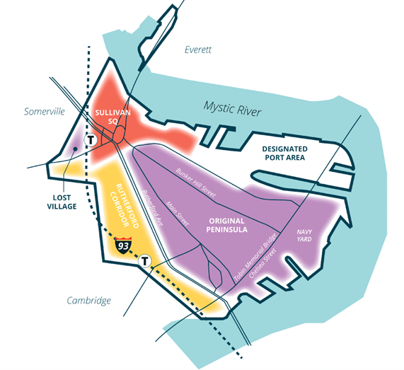
Two Charlestowns
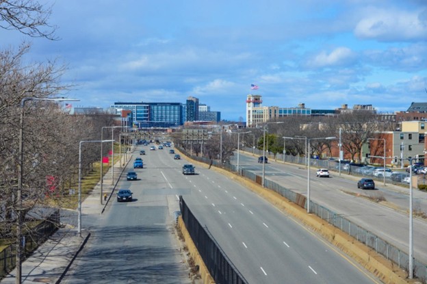
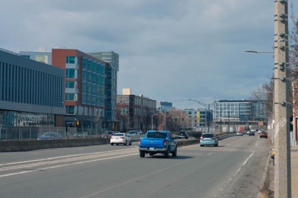
To walk down Rutherford Avenue is to see two visions of Charlestown at once. If one makes their way down from Bunker Hill Community College, they will see on their right the Charlestown of historic triple-deckers and brownstones built up next to one another, the result of more than two hundred years of natural development and construction. On their left, they will see the modern Charlestown: one primarily zoned for industrial purposes and now seeing that push for mixed usage.
Rutherford Avenue runs from one end of Charlestown to the other, from the Bill Russell Bridge, past Bunker Hill Community College, eventually ending at Sullivan Square. On the side that abuts the MBTA’s Orange Line and Interstate 93, there is little in the way of housing. The exception to this? Hood Park, the multiuse housing, dining, and commerce space built into the former Hood Milk bottling plant.
The only things that geographically tie these two versions of the neighborhood are two pedestrian footbridges by the community college and a crosswalk by the hulking concrete triangle that was once slated to be part of the abandoned I-695 Inner Belt project. One of the many tricks PLAN: Charlestown will have to land is how to tie the two together, both geographically and socially.
Kayli Walker and Mike Chulumecky are Charlestown residents. While they live just across Rutherford Avenue from Hood Park, they like to cross over to dine at Tradesman Pizza.
Taking a break from planning their wedding, they expressed both a familiarity with PLAN: Charlestown and a hope that its grand aspirations will be realized. “[The area] is isolated,” Walker says, “but it’s getting better.” They also hope that future developments will match the aesthetic feel of the Charlestown across the Avenue.
Similar questions of connectivity are dogging Sullivan Square. Like Rutherford Avenue, Charlestown’s past, present and future are on display. This includes the Interstate 93 which cuts the neighborhood in two, the shuttered bar Sully’s where local whistles were wetted from 1934 to 2018 and the Schrafft Center office complex. Like Hood Park, the Schrafft building is a former industrial site being reimagined for modern usage.
Hope and Fear at Sullivan Square
The layout of Sullivan Square is its own challenge. The rotary configuration caters to automobile traffic from Boston, Somerville and Everett, which has increased since the opening of the Encore Casino. This came in for heavy criticism during PLAN: Charlestown’s community engagement stages, resulting in multimodal transportation designs being included in the adopted plan. Pedestrians compete with this heavy automobile flow, including many commuters from the MBTA’s Sullivan Square Orange Line stop, as well as cyclists who may be feeling less love from Mayor Wu as of late, given her rollback of traffic safety measures meant to offer them a measure of protection.
One of these Boston cyclists is Collin Fisher. He works at Landry’s Bicycles in Hood Park. A recent arrival from Washington state, he lives in Allston but seldom makes the five-mile bike commute to work. The reasons? “I feel it’s just too dangerous sometimes,” he says, referring to navigating Sullivan Square on two wheels, as well as the aforementioned disconnect between Hood Park and the rest of Charlestown.
The dangerous nature of crossing the premier gateway into Charlestown without a car was echoed by several interviewed for this article. “I don’t have a car,” says Councilor Coletta Zapata. Because she lives in East Boston, “I’m always taking the bus or the Orange Line to get here.”
Meanwhile, longtime resident Nora Moynihan Blake specifically recalled the nerve-wracking nature of crossing Sullivan Square when she was expecting her child, describing it as “dangerous.” The PLAN: Charlestown document says that because of the congestion, “…any new development in the growth areas of Charlestown must use strong transportation demand management tools to emphasize walking, biking, and transit use as preferred options for both residents and workers.” Blake is hopeful that this comes to pass, in addition to being broadly supportive of the overall plan.
Dissent and Disquiet
For all the tentative approval, support for PLAN: Charlestown and its related developments is not unanimous, as can be the case with redevelopment proposals of any size.
Throughout the community engagement process, some residents raised concerns that the proposed redesigns along Rutherford Avenue and Sullivan Square would be too much, too big, too expensive and result in too much congestion. Among the many resident responses, one said, “Cut way back on the overdevelopment. The town will lose its character,” while submitted public comments, appearing to follow a template, invoked the tumultuous development of the Boston Redevelopment Authority (the BPDA’s predecessor agency), saying, “This feels like a second round of Urban Renewal… but without the significant City investments and benefits of Urban Renewal.” [sic]
Additionally, some big business names have taken legal action to halt some projects. The most recent of these is a lawsuit filed in Suffolk Superior Court by Boston Sand & Gravel against the BPDA. The April 7 filing claims that a 705-unit residential project on an offshoot of Rutherford Avenue that leads to its complex will lead to “inevitable” pedestrian deaths, citing the size of the trucks that frequent the area. In a statement to the Boston Globe, which reported the story, a BPDA spokesperson pushed back against the claims of Sand & Gravel without naming them directly, saying multiple safety solutions have been shared and reviewed by both the city and developer before concluding, “The real issue here isn’t about safety — it’s whether some parties are willing to adjust their operations so that we can build hundreds of new transit-oriented homes.”
PLAN: Charlestown in 2026
The plan’s progress has been slow. Three years after adoption, there is little to suggest that PLAN: Charlestown is having a visible impact. There are many reasons for this, with two worth noting specifically.
The first reason is the often glacial nature of urban planning. A plan’s impact unfolds over the course of multiple lifetimes, as generations come, go and leave their marks. If a week is a long time in politics, as former British Prime Minister Harold Wilson famously said, then three years is only a blink of an eye.
The second reason is the economic headwinds now buffeting the region. For a long time, Boston’s economic growth was hitched to the star of housing development. In boom times, government, management and the building trade unions all tended to sing from the same hymn sheet of “build, baby, build.”
“It was a free-for-all” under former Mayor Marty Walsh, Colletta Zapata recalls, with very little room for community voices in her opinion. Now, she notes, development has ground to a halt.
However, signs of forward momentum exist. On April 16, the BPDA approved plans to build 240 apartments – with 48 designated “affordable” – at the Bunker Hill Mall on Rutherford Avenue. This may well ensure PLAN: Charlestown remains a proposal to be frequently referred back to and not one stuck in time.
For now, its supporters and opponents look to events outside of this one square mile neighborhood to see what happens next, and when.